Natural Bridges National Monument: hiking and a snake
On a road trip through the southwest USA Paul and I made a stop at Natural Bridges National Monument in Utah. Not one of the large famous parks in the state, such as Arches or Zion, but none the less beautiful and worth a stop on Utah road trips. Definitely one of Southern Utah’s Hidden Gems.
Where is Natural Bridges National Monument?
Natural Bridges National Monument is located in the southeast of the state of Utah. On the place where the White Canyon and the Armstrong Canyon meet. It’s located south of Moab and east of the Glen Canyon.

Some facts about Natural Bridges National Monument
Utah’s first National Monument was founded on 16 April 1908 and is managed by the NPS. The monument encompasses 3.091 acres. On those acres the Colorado river has winded out a dark-stained white sandstone canyon. The Colorado had different streams which didn’t just run straight forward, but winded back and forth. Between the turns were thin canyon walls. The river kept pounding on those thin walls and they eventually crumbled. This left 3 thin natural bridges. Erosion still has its influence on the bridges. The rock is being made more delicate. In the long run the bridges will collapse. The Natural Bridges National Monument weather consists of hot and dry summers. Temperatures in the summer are mostly in the high 90°s F and over 100°F.

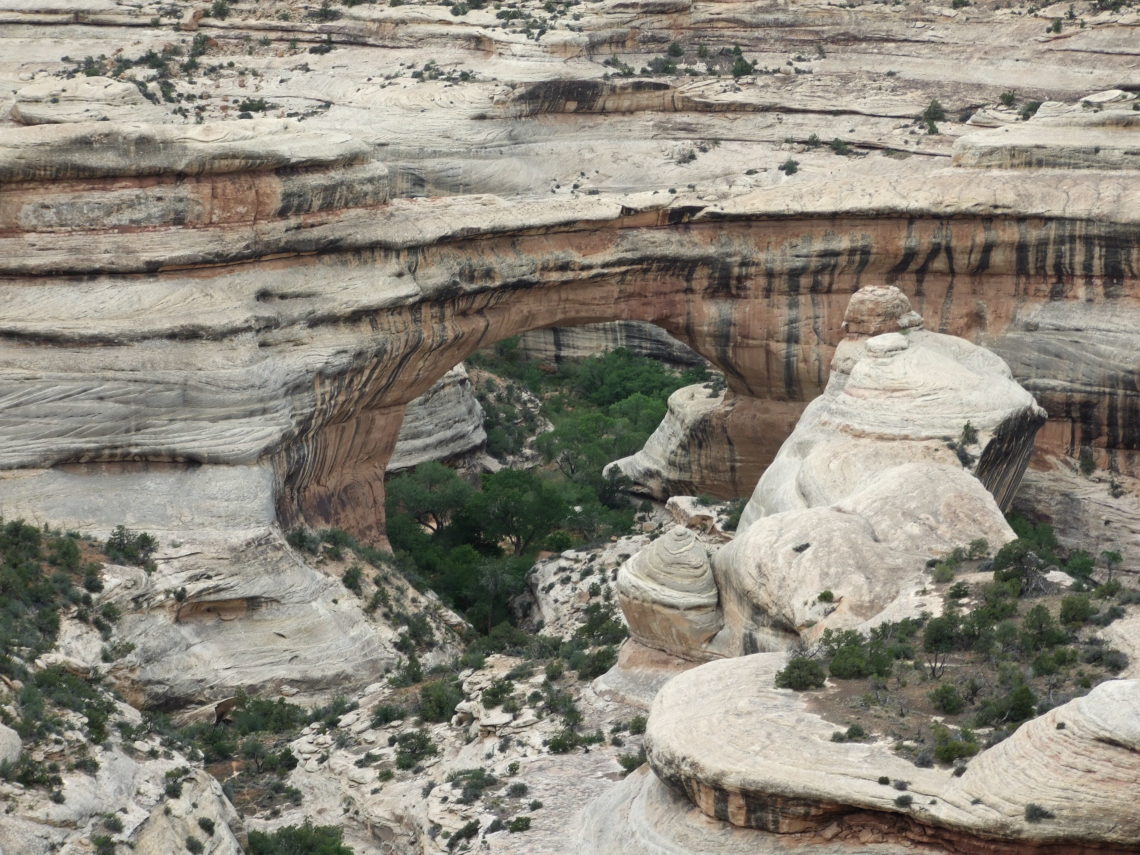
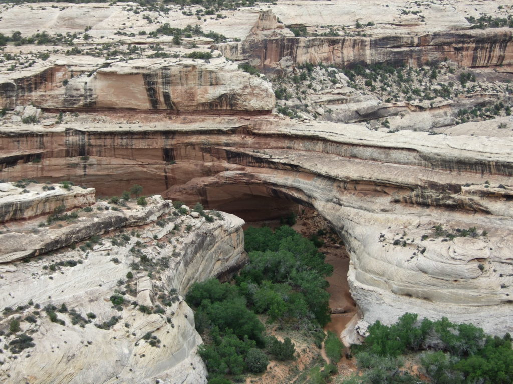
Bridges
There are 3 natural bridges at the monument. They’re named after the ancestral Puebloans who once lived here.

Owachomo bridge is the oldest bridge of the 3. They don’t know this 100% sure, but since it it’s the smallest bridge, they assume this. The Owachomo bridge spans 180ft high with only 9ft thick. It’s the most photographed bridge of them all, and also the most accessible one. Sipapu bridge is the largest bridge of the 3. It’s also the second largest natural bridge in the USA. The 3rd bridge is Kachina which is the youngest and the widest of the 3. All 3 bridges are easily accessible.

Horse Collar Ruin

As mentioned before ancestral Puebloans lived in this canyon. There’s a well preserved Pueblo site visible for hikers. It’s interesting if you don’t want to see nature, but also some human history. This is how life looked like about 700 years ago. We loved seeing the ruins from the overlook. It’s fantastic to imagine how the people used to life here.

Trails
In trails there are 3 kinds of options, short hikes, moderate hikes and loop trails. Depending on the time you have and your condition you can pick your hikes.

Along the main driving loop (14.5 kilometers/9 miles) is an overlook and a trailhead for each bridge and the Horse Collar Ruin. The first one after the visitor center is the Sipapu Bridge Viewpoint. The Kachina Bridge Viewpoint is halfway along the scenic loop drive. The final stop is the Owachomo Bridge Viewpoint. All the trails to the viewpoints are short, half a mile one-way, 10 minute hikes. The Horse Collar Ruin Overlook is a longer hike of about 30 to 45 minutes. You can’t get to the ruins, only get a birds-eye view. We did all these hikes and enjoyed the beautiful views. On the Horse Collar Ruin we even saw a snake.

There are 3 moderate hikes, to each bridge one. The ones to Sipapu and Kachina are 1 to 2 hours long. The one to Owachomo is a half-mile round-trip hike that takes 20 to 60 minutes, this is the hike most people take.
The 3 loop trails are all primitive and strenuous. The Full Loop passes all the 3 bridges and goes over the mesa top and is 15.8 kilometers (9.8 miles) long. The Sipapu-Kachina loop is 9.2 kilometers (5.7 miles) and the Kachina-Owachomo loop 10.5 kilometers (6.5 miles), both pass the named bridges and go into the canyon.
What else is there?
Besides these things there’s a Solar Panel Field, which completely powers the monument, you can make a stop here. The Natural Bridges National Monument Utah was named the first International Dark Sky Park on 6 March 2007. The park has some of the darkest skies in the USA.
Address:
Lake Powell
UT 84533
USA
(435) 692 – 1234
The entrance fee is $20,00 for one car, a motorcycle is $15,00 and for a person without a car is $10,00. For 15 and under, entrance is free. With a $55,00 Southeast Utah Parks Annual Pass you get admission to the monument, Arches and Canyonlands for a year. Standard opening hours are from 9 am to 5 pm, Thursday to Monday.
Conclusion
We loved our visit to Natural Bridges National Monument ut, the bridges, the views, the ancestral site and seeing a snake were all highlights. We spent about 2 hours at the park.
Like it? Pin it!

Like it? Pin it!


38 Comments
Kariss Ainsworth
What a stunning landscape
Cosette
Yes, it was really stunning. Loved wandering around in the park.
Margarida Vasconcelos
This seems to be a great place for hiking. Thanks for sharing.
Cosette
Yes, it’s a perfect place for hiking. Lot’s of options to choose from.
Devin Held
Oh wow. I’ve never seen anything like these natural bridges! Did you walk across them???
Cosette
We didn’t get to walk across them, your not allowed too. Since they’re fragile. They were beautiful to gaze at.
Tia
Wow looks incredible! I would be sooo tempted to walk across one of those fragile bridges and kill myself in the process!!
Cosette
Yes, I think that’s one of the reasons it’s not allowed to walk across them and for there preservement.
Kelly Francois
Natural Bridges Monument is gorgeous. However I’d be running pretty quick if I came across that snake lol. I love hoe the tribal ruins have been kept in place.
Clazz - An Orcadian Abroad
I completely missed this when I was in Utah!! It looks beautiful. That snake is blimmin’ huge too!
Cosette
I can understand that you missed it, Utah is jam packed full of things to do. National parks, adventure and more beautiful nature. Next time your in UTah, Natural Bridges is well worth your time.
Katie Goes
Oh my goodness – the snake! Is it dangerous? How do you know out there? Did it move?
Cosette
I honestly don’t know if that snake is dangerous, it did move, but not towards us and we didn’t come to close to it. My husband loved seeing that snake.
MEM
That’s a rattlesnake. They are venomous and fairly common in the area.
Amanda OBrien
wow that looks amazing! and your photos are fantastic!
Cosette
Thanks and yes it was fantastic.
Portia Jones
I love off-beat places like this and reading more about alternative destinations. I love the sound of the loop trails and I’m actually a fan of snakes. 🙂
Cosette
Yes, those loop trails are something for when we get to go to Utah again someday. My husband was also really pleased to see the snake.
Hannah Swader
Utah is gorgeous and I’ve always wanted to go hiking there! Can’t wait to check this out one day.
Cosette
Utah is a perfect state for hiking, there are so many opportunities there.
Marguerite
I love places like this that combine adventure, history and nature. Definitely another one for the bucket list! Greetings from Berlin, Germany 🙂
Cosette
Yes, it’s a perfect combination. And greetings from Utrecht, The Netherlands.
Lauren
I’ve actually never heard of this park, which is so weird as I traveled through Utah with my parents in their RV! But then again, there are so many amazing natural sites within Utah! Thanks for putting the Natural Bridges National Monument on my radar! And wow- that snake would have REALLY freaked me out haha
Cosette
Yes, Utah is so jam packed full of beautiful natural sites. We’ve done a few back then on our road trip and I have heard of enough sites since then, to make a few more road trips through Utah.
Lisa | Handmade in Israel
Such incredible scenery. Imagine living in that landscape. Not sure about the snake though! #WanderfulWednesday
Cosette
Yes, it would be wonderfull to live in that landscape.
Cynthia
Whoa – was it a rattlesnake? Sort of looks like it, but I can’t tell completely from the photo. Looks like you had an incredible trip – I’d love to visit this area of the States someday!
Cosette
Actually have no idea what kind of snake it was. Don’t think a rattlesnake, since it didn’t give a sound. We indeed had an incredible trip. Southwest USA is a beuatiful part of the country.
Brittany
Horse Collar Ruins look so cool! We almost went there on our road trip through Utah. So many gems there!!
simplyjolayne
I chuckled to see “and a snake” in the heading. This is an area I have wanted to visit and go hiking. The landscape is beautiful. Can you imagine living there so many years ago?
Krista
As soon as I see a snake I am out of there! Although the natural arches would definitely be more of a highlight for me as long as I didn’t see more than one snake.
Caroline Rita Muller
Gosh these geological formations are exceptional. The snake however would totally put me off going haha!
ildiko
I love Natural Bridges. Such a beautiful landscape. I would also love to see the Horse Collar Pueblo ruins. Very, very cool! The snake I would prefer NOT to see. LOL!
Kitti
I just love natural arches and bridges even though I know they’ll most likely going to collaps at some point in the future. Definitely want to visit this area and it’s good to know about the hiking trail. Thanks for sharing.
Elyse
I love this, I’m always looking for special places to go hiking and Natural Bridges looks so beautiful! Not sure how’d I’d feel about seeing the snake though lol
Jan
I love natural bridges! They are so cool. I have not been to this part of USA yet, but looks like a good idea to check it out. The best thing is that along with the views of natural bridges, there are doable hikes! Not looking forwards to snakes though! 🙂
Charlie Karin
This is stunning with some beautiful hikes! I love that you can see teh ruins from a birdseye view! I missed this stop when I was in Utah last, it’s on the list for the next visit however!!
Lorraine Caputo
I concur with other commenters: The snake you came across is a rattler (rattlesnake) — you can tell by the shape of its head and the rattle at the end of the tail. (It has shed its skin at least five times, from what I could count — so probably 2-3 years old. Very venomous.